This post may contain affiliate links. This means we may receive a commission (at no cost to you) if you click a link and make a purchase.
The Adirondack Mountains in Upstate New York are full of outdoor activities. Home to the 46 High Peaks, the Adirondacks can be intimidating to a new hiker looking to explore some of the nearby mountains. As more and more people flock to the High Peaks, local organizations have been putting together hiking challenges with shorter trails to encourage people to check out parts of the Adirondacks they may not ordinarily see. One of the newer hiking challenges in the area is the Lake Placid 9, a set of 9 trails covering 30+ miles throughout the Lake Placid region. If you’re planning a trip to Lake Placid in the summer, hiking some of these incredible trails should definitely be on your list.
Cobble Hill


- Location: Lake Placid, NY
- Distance: 2.2 miles
- Elevation Gain: 485 feet
- Trail Markings: Good
Cobble Hill is the shortest and one of the easiest options of the Lake Placid 9er. It’s a good place to start your journey to becoming a 9er and is right near downtown Lake Placid. Don’t let the pictures fool you, going up or down Cobble Hill’s short trail is no joke. Cobble Hill features a short loop with a half mile “short trail” and a “long trail” that’s about double the distance that join together for the hike to the summit. The short trail may sound like the better option at around half a mile, but be prepared to scramble up some steep rock face. You’ll need to use both your arms and legs. If you do plan on making it a loop, I’d suggest hiking up the short trail and down the long trail. Either way I definitely wouldn’t attempt the short trail in rain as the rock could get slippery. My personal favorite part of the trail is the section along the nearby pond. It’s relatively flat and makes for a lovely stroll.
Mt. Jo

- Location: Lake Placid, NY
- Distance: 2.6 miles
- Elevation Gain: 692 feet
- Trail Markings: Good
From the top of Mount Jo you can see a stellar view of not only some of the Adirondacks, but also beautiful Heart Lake. Here we chose to park in the Adirondack Loj parking area after finishing nearby Mt. Van Hoevenberg and walk down to the beach along the lake prior to beginning our climb. While it does cost money to park in the Adirondack Loj parking area, we saw a considerable number of people parked along the road with tickets on their windshields. I don’t know about you, but I personally would much rather pay for parking that is less than $10 than a $100 parking ticket.
The hike up Mt. Jo is similar to Cobble Hill. There are two paths you can take, a shorter trail that is significantly rockier and steeper and a longer trail. We chose to go up the short trail and down the long trail. While quite strenuous up the short trail, I think it was actually a bit easier than going up Cobble Hill. While Cobble Hill had large areas of exposed rock, Mt. Jo featured more smaller rocks to climb from point to point, making it a bit easier to find footholds. A word of caution when tackling any of these trails— in the summer there are is a good chance you’ll see (or at least hear) some timber rattlesnakes in the woods. Be sure to give them a large berth and be listening for their rattle; we heard them here on the long trail of Mt. Jo.
Baxter Mountain

- Location: Keene, NY
- Distance: 2.4 miles
- Elevation Gain: 741 feet
- Trail Markings: Excellent
Baxter Mountain ended up being one of my favorite hikes of the Lake Placid 9. While the trail is on private property, the owner graciously opens their land to hikers and it is incredibly well maintained with clear trail markers. There isn’t a proper parking lot, but there is a sign designating parking for Baxter as you pull off to the side of the road. Unlike some of the other more popular hikes in the Adirondacks, there were only a few cars here and for most of the time we had the trail to ourselves.
Read: How To Hike Your First Adirondack High Peak: Cascade Mountain
Mt. Van Hoevenberg

- Location: Lake Placid, NY
- Distance: 5.6 miles
- Elevation Gain: 892 feet
- Trail Markings: Ok
Mt. Van Hoevenberg is home to the bobsled and luge tracks from the Lake Placid Olympics. Unfortunately it has been under construction while we are completing the challenge and the track can’t be seen from anywhere on the mountain. Since the site is under construction, there were some modifications made to the trail and it took us a bit to actually find the start of the hike. As you pull into the Olympic Center where the biathlon events were held, there is a parking lot on the right to park and then you walk across the bridge over the main road to a section of ski trails. The first part of the trail intersects with these ski trails as mountain bike trails for the good first mile or so of the hike. There are some good views from the top of the mountain, but it took us a little longer than expected to get there. Alltrails states the distance of this trail as around 4.5 miles, but it was about a mile more than that round-trip. Some of this may be due to the construction on the trail. Overall, not my favorite hike of the set but a solid one to start testing your distance for the hikes later on.
Big Crow Mountain

- Location: Keene, NY
- Distance: 1.4 miles
- Elevation Gain: 597 feet
- Trail Markings: OK
Big Crow Mountain is short at only .7 miles up, but the trail still got our hearts racing and quads burning as we made our way up (especially since we had done two hikes on this list the day before). Once you get into the woods the trail snakes straight up to the top, where you’ll find a cairn placed to signal the top of Big Crow. The trail does continue on to nearby Little Crow, but it isn’t required for this challenge.
Pro Tip: Be sure to get to Crow’s Clearing (the trailhead at the end of O’Toole Road) early in the morning if you can. We were there between 8 and 9 and there was already very limited parking in the area.
Bear Den Mountain
- Location: Wilmington, NY
- Distance: 4.5 miles
- Elevation Gain: 1,479 feet
- Trail Markings: OK
A quick Google search for Bear Den Mountain leads to multiple options in the area. You’ll want the one in Wilmington, NY, right near the Whiteface Ski Lodge. Pull into the lodge and then find the “Bear Den Lot” to your right. The trailhead is over to your left, Trail #12. The bottom portion of the trail can be a bit confusing since the colors of the trail markers change from red to yellow and then back to red (at least when we made the hike in August 2019) and is also a mountain biking trail. We chose to take this hike a bit later in the day and were rewarded with spectacular sunbursts over Whiteface Mountain.
Pitchoff Mountain

- Location: Keene, NY
- Distance: 5.2 miles
- Elevation Gain: 2,132 feet
- Trail Markings: Good
The trailhead for Pitchoff Mountain is located along Route 73 in the same parking area as one of the Adirondack High Peaks, Cascade Mountain. We hiked Cascade last year and had a blast, but the biggest issue with hiking in this area is parking. Local officers are cracking down on parking along Route 73 and there are a very limited number of spots. We were lucky enough to snag one last time, but I recommend going extremely early to secure a spot if possible. The other option is to avoid weekends and holidays, as the area can be less crowded. If you’d like to take the short detour to Balanced Rock, park at the Cascade Pitchoff parking lot. Otherwise you could take two vehicles and do this as a through hike between Pitchoff East and Cascade Pitchoff lots, but again this is not recommended due to the amount of congestion in this area of Route 73.
Read: Hike Upstate New York in 5 Miles or Less
Catamount Mountain

- Location: Wilmington, NY
- Distance: 3.9 miles
- Elevation Gain: 1,571 feet
- Trail Markings: OK
Catamount Mountain may not seem the most difficult of the trails, but it can be a bit tricky with some steep elevation gains. There were recently trail markers added to keep you on track; we only got off the trail once, but you’ll need to pay attention to make sure you’re heading in the right direction. The path does border some private property, so be sure to avoid wandering into those areas on your hike. The highlight of the trail is the rock scrambles at the top through some pretty tight spots. This definitely pushed some of Mike and I’s limits with climbing, but it was fun to mix things up.
Hurricane Mountain (Northern or Southern Ascent)


- Location: Keene, NY
- Distance: 6.8 miles (5.6)
- Elevation Gain: 2,017 feet (1,528 feet)
- Trail Markings: OK
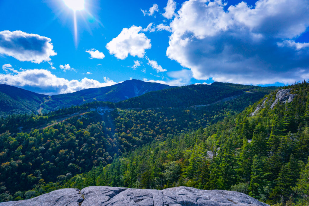
Hurricane Mountain is arguably one of the most difficult of the nine due to its longer distance and higher elevation gain. You have the option to hike from the Northern or Southern Ascent. You can access the northern ascent from the Crow’s Clearing parking lot or the southern ascent from Route 9N. We chose to use the northern ascent up to the summit and the fire tower perched on top. The beginning part of the trail is relatively flat as you walk back towards the primitive campsites and veer up to the right towards the summit. We did get slightly off trail once; my only complaint is that there are some sections where you can’t see the next marker from the previous one to be sure you are on the right path.
While this is the longest hike of the bunch regardless of the ascent you choose, you are rewarded greatly for your efforts with 360 degree views of the Adirondack region. It is nothing less than spectacular, so plan some time up here for a picnic and a chance to go up the fire tower if you like. Pictures really don’t do these views justice.
Pro Tip: If planning to hike Big Crow and Hurricane from Crow’s Clearing in one day, do Big Crow first. Once you finish with Hurricane you won’t want to head up another mountain afterwards.
Lake Placid 9er Registration
Does this sound like a ton of fun and now you want to be a Lake Placid 9er? All you have to do is keep track of the dates you climb each peak and once completed fill out the official Lake Placid 9er Registration Form. Send the form along with a $10 check and in a few weeks you’ll receive a Lake Placid 9er patch for your backpack. If you sign up for my newsletter below you can get a free printable tracker to track your progress.
How Did We Do It?
To finish the challenge we spent 5 days hiking in Lake Placid on the weekends:
- Day 1: Mount Van Hoevenberg and Mount Jo
- Day 2: Cobble Hill and Baxter Mountain
- Day 3: Catamount Mountain and Bear Den Mountain
- Day 4: Big Crow and Hurricane Mountain
- Day 5: Pitchoff Mountain
What Gear Should I Bring to Hike the Adirondacks?
If you’re planning to tackle the Lake Placid 9, you’ll want to be sure you’re prepared for the journey. You can check out our Gear section of the website for all of our camping and hiking gear, but you definitely want to make sure you have a good set of hiking shoes, plenty of water and snacks, and some bug spray. Hiking poles and a solid backpack can also help, especially if you are planning for multiple hikes in one day like we did.
Need a Bigger Challenge?
If this sounds like a walk in the park, there are several other options including doing the Ultra Lake Placid 9er (all 9 hikes within 24 hours) or the Winter Lake Placid 9er (all hikes completed between December 21-March 20). You can also take on the Saranac Lake 6er or the Lake George 12ster if you’ll be doing a lot of hiking in the region, or even tackle the 46 Adirondack High Peaks to become a 46er. I personally can’t imagine doing these in winter or all in one day, but we had a blast working our way through the challenge on weekends.
Planning to do the Lake Placid 9er Hiking Challenge? Pin this post for later!

